2 Hours/5kms
Easy Level
We are in Porto de Muge a village in the lands of Cartaxo, a region known for its wines. In this Hiking we will propose a short journey that ends with local a Wine Tasting(*). Along the walk you will visit this picturesque village where the Marchanta is inserted, during which you will be able to observe the Tagus River, an essential geological element, visit a centuries-old bridge that transposes it, have a drink together with the locals and taste a wine in a local winery. During this journey, you will walk on a millenary dam originally built by the Arabs which today stands like a belvedere contiguous to the river.
* For the Wine Tasting, you need to contact the winery:
Casal do Conde
Rua do Sabugueiro – Porto de Muge
(+351) 243 789 255
info@sacasaldoconde.com
This proposal includes a visit to the local heritage.
The route that we are going to do is a walk along the village that has developed parallel to the river. We will culminate in the district of Rossio, where the town began and where it took its name due to the river port and the boat that allowed to cross the river, to arrive at the town of Muge in the opposite margin.
Leave the Quinta da Marchanta heading the river exit and head northwest turning left. Right after the Quinta da Marchanta, the dam has a vegetal cover. At this point, you should follow the narrow tar-road.
On your left is an old nunnery founded in 1832. Unfortunately we can’t visit it. Go ahead.
Go forward with the dike on your right side. Further on you will find the neighborhood of Morgado, formed by the community of workers who once lent their labor to a farm of the same name. Most of the neighborhoods in this village have formed from this logic.
When you reach the beginning of the neighborhood, even before the embankment is once again covered with rock, you will find a pedestrian ramp. Climb up the ramp to the top of the dike to observe the landscape. The path will be over this millenarian construction.
Go ahead a few yards right after the first house. On the right side, there is a hydrometric scale dating from 1877, used until recently to communicate the levels of the waters of the Tagus River. The conviviality with the river is a strong component of life in these stops. On the one hand it is essential for this community composed by fishermens, boatmens and farmers, on the other hand in rainy years rises to undesirable levels. The network of levees has always served to defend the community in these critical years. Let’s move on.
Go through the neighborhood over the dam. Throughout this neighborhood, you will step on the same stones as the writer Maria da Graça Freire, an important figure of the century’s literature. XX, and the same ones that the footman of the Benfica player, Jose Rosário, crushed in the first international conquest of the club. At the point where the dam makes a depression near the blue house, it was once on the right side, a fertile port from which goods were dispatched and arrived. At this point, the vernacular architecture of the “Avieros” neighborhood prevails, a community that left the sea to dedicate itself to fishing in the river.
Continue forward. The bridge begins to glimpse in the background.
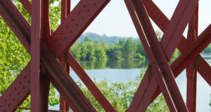
Now that you are facing the side of the bridge it is time to visit it. Turn left across the street to reach the staircase that leads to the traffic lights of the bridge. Turn to the bridge entrance. Here you can see the interior of this railway bridge, which King D. Carlos inaugurated in 1904, and which he named after Queen Amelia.
At the top of the arch on the entrance, it appeared in the last times of the monarchy, a coat of arms allusive to it, that the people destroyed by the times of the republican revolution in 1910. Today the bridge is affected to the transit road, and the central way serves this transit, so follow the passage on the right that is affecting the pedestrians. Keep going forward but now on the way to the river.
This bridge, over which you walk, was built in the style of iron architecture. At the time it allowed the connection betwin the rail network of the north and the southern railroad, being the point of crossing of the Tagus river more to the south. With 800 meters of board, it was at the time the longest Iberian bridge.
Walk forward and go discovering the landscapes that the river is revealing. Continue to overlap an islet in the river, where the vegetation creates the habitat for several river birds.
Contemplate as long as you want, until you decide to return.
Take the same path back to the top of the dam. From here go forward, passing under the bridge taking advantage of the landscape that is revealed below. You will reach a point where the top of the dam is again interrupted by the vegetation cover.
Go down the stairs that lead you back to the tarred street. You should move on until you find the next neighborhood.
At the beginning of this neighborhood you can find one of the village’s coffee shops, and where you can have a drink, before resuming the walk.
Return to the path taking the same direction parallel to the dam. Return to the top of the dike where the landscape is more pleasant. In the streets of this neighborhood, once circulated the bicycle of the cyclist Ezequiel Lino, twice vice-winner of the Portugal Tour.
You are getting to Rossio, the original neighborhood of the village, where once the river port existed. It is the only neighborhood that is unprotected by the dam, at the side of the river bed in relation to it. It is a sign that we are getting to Casal do Conde to taste a wine. Go down the stone ramp that you find in the front, go around the farm wall to the left and enter through the main gate.
Return to Marchanta along the same path.